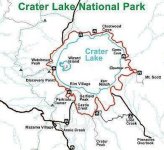
I looked into the type of road the rim trail is, sounds like a lot of broken up pavement, nothing extreme. At the same time, may not be a horrible idea, as if somebody were to break down for whatever reason due to trail riding, it is a long trip back to civilization. Anyways, I have included a map of the trail which is in RED, and also here is some information about the trail
Jason
Toms Bronco Parts
800-749-5028
TRAIL DESCRIPTION:
Rim Drive is located high in the Cascade Mountains. At its lowest point, Rim Drive is 6,500 feet (2,000 m) above sea level. The road reaches almost 7,900 feet (2,400 m) at its highest point on top of Cloudcap. Rim Drive has eight main viewing areas with roadside parking. Four of these observation points (Pumice Point, Skell Head, Cloudcap, and Kerr Notch) are located just off the road. Short trails from parking areas lead to the other four observation points (Sinnott Memorial, Discovery Point, Watchman Lookout, and Merriam Point). In addition to the main viewing areas, there are 15 turnout vista points along the road.
Heading northwest from the Crater Lake National Park headquarters in the Munson Valley Historic District, it is three miles (5 km) to Crater Lake rim and the Rim Village visitor area which is also a historic district. The Sinnott Memorial overlook is located in Rim Village. Leaving Rim Village, the speed limit is reduced to 35 miles per hour (56 km/h). Visitors reach the Discovery Point viewing area in just over one mile (1.6 km). From there, it is five miles (8 km) to the junction with the North Entrance Road. Between these two way points visitors pass over the 7,350 feet (2,240 m) West Rim Summit. The section of Rim Drive between Rim Village and the North Entrance Road is known as West Rim Drive. This part of the road is used heavily during the summer because it is the direct route between the park’s north and south entrances and passes by the Rim Village visitor area and the park headquarters at Munson Valley. It also offers classic views of Crater Lake and Wizard Island along the way.
Rim Drive looking south toward the North Entrance Road junction and Merriam Point parking areaContinuing north on Rim Drive past the North Entrance Road junction, visitors traverse the back side of Llao Rock. This is the beginning of East Rim Drive. The next turnout for viewing the lake is approximately two miles beyond the North Entrance Road junction. Viewpoints along East Rim Drive are generally not crowded except at the Cleetwood Cover parking area which is at the north end of Crater Lake. Cleetwood Cove is the trailhead for the only hiking trail down into the crater. The National Park Service maintains a marina for boat tours at Cleetwood Cove.
Beyond Cleetwood Cove, Rim Drive becomes a one-way road running clockwise around the lake rim. Along this section of East Rim Drive there is a series of seven turnout-parking vista points. These turnouts retain almost all of their original stone masonry and offer spectacular views of Crater Lake. The first of these view points is located above Grotto Cove, about halfway around the lake from Rim Village. The next viewing area is Skell Head, about a half mile from Grotto Cove. The next five vista points are spread over the approximately seven miles. These stops are Cloudcap, Cottage Rocks, Sentinel Point, Reflection Point, and Kerr Notch. Each site provides a unique view of the lake and surrounding landscape include Mount Scott.[6]
Rustic stone guardrail at Skell Head viewing areaKerr Notch, located 21 miles (34 km) from Rim Village, is the last observation point on the Rim Drive loop with a view of the lake. After leaving Kerr Notch the road cuts across the east face of Dutton Ridge offering a spectacular view of the Klamath Basin from near the East Rim Summit. Rim Drive then descends to the Sun Notch trailhead where visitors can hike to another viewpoint overlooking the lake. Rim Drive continues along the outer edge of Sun Meadow to a parking area in front of Vidae Falls, a 100-foot (30 m) cascade. Vidae Falls has a picnic area and a trailhead to a cinder cone called Crater Peak.
The final two miles (3 km) of Rim Drive passes by the Castle Crest Wildflower Garden. The half mile long Castle Crest Nature Trail takes visitor through a wetland wildflower meadow. The wildflower display is at its peak in July and August. Rim Drive terminates a half mile from the Castle Crest parking area, at the Munson Valley Road junction near the park headquarters and visitor center.